
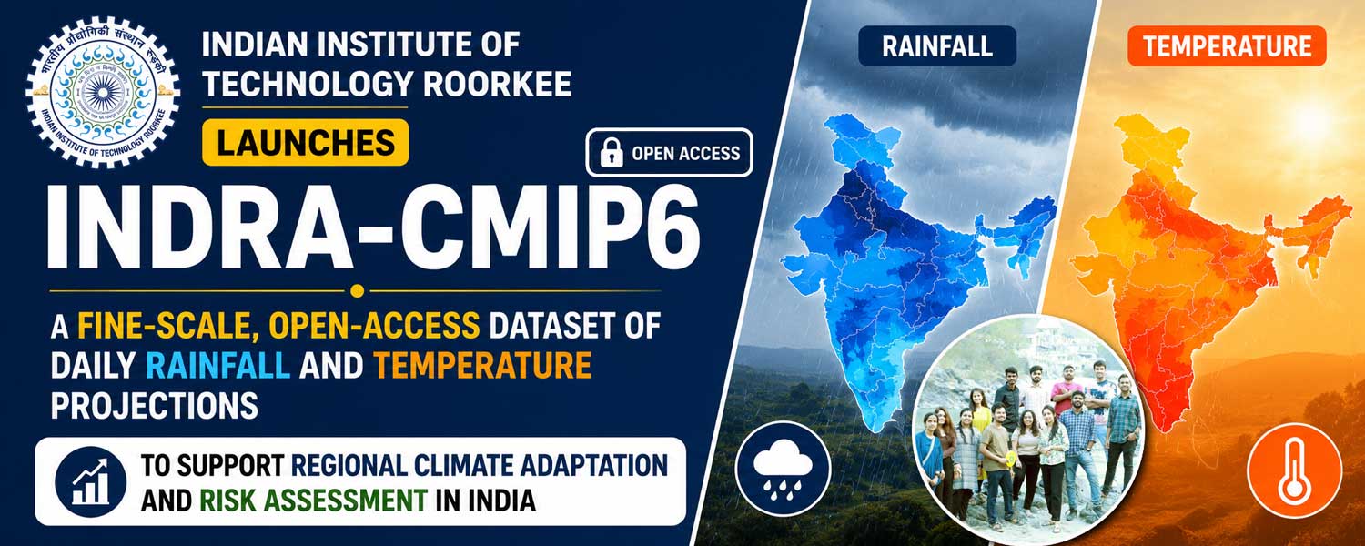
IIT Roorkee launches INDRA‑CMIP6, a fine‑scale, open‑access dataset of daily rainfall and temperature projections to support regional climate adaptation and risk assessment in India.
Open‑access dataset for fine‑scale projections
Researchers at the Indian Institute of Technology Roorkee (IIT‑R) have released INDRA‑CMIP6, a high‑resolution, open‑access climate‑projection dataset for the Indian subcontinent. The dataset provides daily rainfall and temperature projections at a spatial resolution of nearly 10 kilometres (0.1° × 0.1°) across both historical and future climate scenarios. By bridging the gap between global climate models and local‑scale adaptation needs, INDRA‑CMIP6 helps planners, researchers, and policymakers generate more realistic risk assessments for disaster preparedness, regional adaptation, and climate‑resilient infrastructure.
Published in Scientific Data (Nature Portfolio), the dataset provides daily rainfall and temperature projections for the Indian subcontinent at nearly 10-km resolution across historical and future climate scenarios. The initiative is expected to support climate adaptation planning, disaster preparedness, water resource management, and climate risk assessment. Joyjit Mandal, Divya Sardana, Akash Singh Raghuvanshi, and Prof. Ankit Agarwal authored the study.
The initiative directly addresses a key limitation of global climate models, whose coarse resolution often fails to capture India’s complex terrain, monsoon variability, and regional extremes in rainfall and temperature. INDRA‑CMIP6 enables users to move beyond continental averages and work with data that better reflect district‑level and river‑basin‑level climate behaviour.
Tackling India’s growing climate risks
India is already experiencing intensified climate‑change impacts, including rising temperatures, erratic monsoon patterns, urban flooding, heat stress on workers and crops, and growing pressure on water resources. To respond effectively, decision‑makers need climate projections that accurately represent local conditions, particularly in monsoon‑driven and topographically diverse regions such as Himalayan watersheds, coastal zones, and drought‑prone interiors.
Adaptation decisions – such as strengthening embankments, designing urban drainage systems, and selecting climate‑resilient crops – require climate information at district and river‑basin scales, not broad national or continental summaries. INDRA‑CMIP6 satisfies this requirement by delivering high‑resolution, time‑series data that can feed into hydrological models, urban‑flood simulators, and agricultural‑impact assessments, supporting more targeted and evidence‑based planning.
Methodology and technical improvements
The INDRA‑CMIP6 dataset is developed at the Department of Hydrology, IIT‑R, and published in Scientific Data (Nature Portfolio). The team used outputs from 14 CMIP6 global climate models and applied the Double Bias‑Corrected Constructed Analogue (DBCCA) statistical‑downscaling method. This approach first corrects systematic biases in the raw model outputs and then refines the projections by matching them to historical observations, thereby improving the representation of daily weather variability, regional rainfall patterns, and temperature extremes.
The dataset provides daily precipitation, minimum temperature, and maximum temperature at 0.1° × 0.1° resolution and includes both individual model outputs and a multi‑model ensemble. This structure allows researchers and planners to compare different projections, analyse uncertainty, and avoid relying on a single model pathway when assessing future climate risks.
Four Socioeconomic Pathways and scenario flexibility
INDRA‑CMIP6 incorporates four Shared Socioeconomic Pathways (SSPs), which represent scientifically informed futures under different development and emissions trajectories. SSP1‑2.6 depicts a low‑emission, sustainable future where strong climate action and cleaner energy keep warming low. SSP2‑4.5 describes a middle‑of‑the‑road scenario with moderate warming and some climate‑mitigation efforts.
SSP3‑7.0 reflects a high‑emission, fragmented world with limited cooperation and substantial adaptation challenges, while SSP5‑8.5 portrays a very high‑emission, fossil‑fuel‑intensive future often used to examine worst‑case warming and extreme‑risk conditions. By including all four scenarios, the dataset enables analysts to explore how climate risks – such as heatwaves, heavy‑rainfall events, and droughts – vary under different emissions and development choices, informing both mitigation and adaptation strategies.
Validation, accessibility, and intended users
Technical validation indicates that INDRA‑CMIP6 substantially reduces systematic errors in raw global‑model outputs and improves the representation of extreme rainfall and extreme temperature days, especially in regions where local topography and monsoon dynamics dominate risk. The ensemble datasets are available through Zenodo, while the full downscaled and bias‑corrected individual‑model outputs are hosted on Google Drive. With a total size of around 2.4 terabytes, it ranks among the most detailed open‑access climate resources currently available for the Indian subcontinent.
The dataset targets university researchers, government departments, river‑basin authorities, disaster‑management agencies, urban planners, and agricultural institutions. It can support basin‑scale hydrological modelling, flood‑and‑drought risk assessment, climate‑resilient infrastructure planning, crop‑impact studies, and local‑adaptation strategies. The initiative aligns with India’s priorities on climate resilience, disaster‑risk reduction, sustainable water management, and evidence‑based planning under national and global sustainability frameworks.
Institutional leadership and vision
Professor Ankit Agarwal, Department of Hydrology, IIT‑R, emphasised that India’s climate risks are highly localised, particularly in monsoon‑driven and mountainous regions. “Fine‑scale climate projections such as INDRA‑CMIP6 are critical for translating global climate science into actionable information for planners, researchers, and policymakers,” he said. “Open access to such datasets strengthens scientific collaboration and supports informed climate‑adaptation strategies.”
Professor Kamal Kishore Pant, Director, IIT‑R, added that climate change represents one of the most pressing challenges of the present era and that scientific institutions have a responsibility to develop accessible, reliable knowledge resources. “INDRA‑CMIP6 reflects IIT Roorkee’s commitment to advancing high‑impact research that supports climate resilience, sustainable development, and evidence‑based policymaking for India and the wider region,” he said.
Disclaimer
The information in this article is based on available public sources and official statements as of the time of publication. While we aim for accuracy, we do not guarantee completeness or correctness. We advise readers to verify key details from official sources before making any decisions. The website (iitiimsamvaad.com) is not liable for any loss or damage arising from the use of this content. The authors are also not responsible for any such loss or damage.